C10 – Spiazzi/Croce/Santuario della Corona
A way to discover the origins of the devotion of the Madonna della Corona, views of Lake Garda, Monte Baldo and Valdadige. A beautiful view.
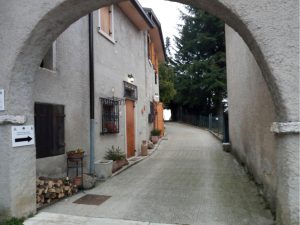
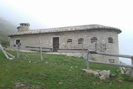
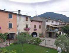
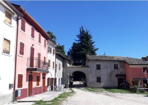 Nel primo medioevo c’è chi ritiene la Croce fosse un Monastero. Sta di fatto che le relazioni dei visitatori del Baldo tra il ‘500 e il ‘600, quando giungono a toccare questi luoghi, parlano del Santuario mariano della Corona e citano soltanto l’abitato dei Crosatti famiglia storica della zona come ostello. Verso la fine dell’ottocento il centro del paese era la Croce chiamata anche la piccola Parigi, poiché dotata di osteria (al Lampione) un alloggio, affittacamere, una scuola elementare privata e anche una stazione delle guardie di Finanza la cui caserma era posta nella corte. Vi abitavano circa cento persone, alcune officine con una ventina di lavoratori di oggetti religiosi in osso, la materia prima erano i stinchi di bue lavorati con l’aiuto della lima e del tornio, attività artigianale che rimase attiva fino ai primi decenni del novecento. La corte era originariamente chiusa con quattro porte di protezione, “Porta viveri”, Porta Lupi o Viandanti, Porta Latrine e Porta Morti dove si usciva per raggiungere il Cimitero di Ferrara.
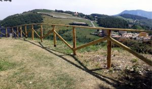
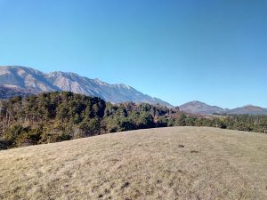
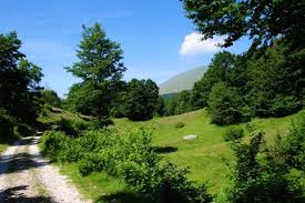
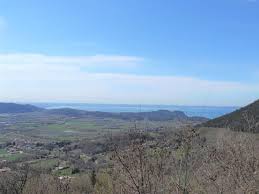
 Uscendo dalla Porta si prosegue sul sentiero con una staccionata, questa è un Panoramic point dove si può ammirare da sinistra verso destra i Monti Lessini, il Corno D’aquilio, Fosse, Erbezzo; al centro la valle Lagarina il Monte Cimo e l’abitato di Spiazzi, la pianura padana, il lago di Garda e il Monte Baldo.
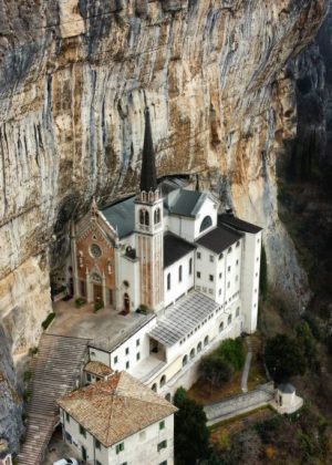
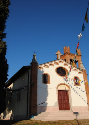
 Al termine del sentiero teniamo la destra e attraversiamo il piazzale Giovanni Paolo II dove una strada o in alternativa gli scalini ci portano al Sanctuary of the Madonna della Corona:
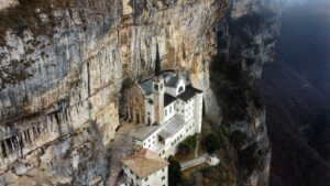 Suspended between heaven and earth, from this marvellous 16th century sanctuary you can have an extraordinary view of the Valdadige.
Return back on the same path, keep left and you arrive at the starting point in the small square of Spiazzi.
Suspended between heaven and earth, from this marvellous 16th century sanctuary you can have an extraordinary view of the Valdadige.
Return back on the same path, keep left and you arrive at the starting point in the small square of Spiazzi.
To be seen
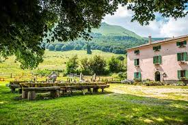
The Sanctuary of the Madonna della Corona, the Village with its characteristic wooden houses, the Croce contrada, the original core of Spiazzi. A way to discover the origins of the devotion of the Madonna della Corona, views of Lake Garda, Monte Baldo and Valdadige. A beautiful view. Si parte dalla piazzetta Don Luigi Vezzola, attraversando il passaggio tra l’Albergo Corona e il ristorante di fianco, si raggiunge la Strada Graziani, scendendo a sinistra una decina di metri si trova a destra la stradina che passa in mezzo alle abitazioni e imbocca il sentiero che porta al Villaggio con le tipiche costruzioni di legno, giunti al bivio si tiene la destra dove il sentiero sale e porta alla contrada Croce, il nucleo storico più antico di Spiazzi.Wooden buildings
Croce contrada
Nel primo medioevo c’è chi ritiene la Croce fosse un Monastero. Sta di fatto che le relazioni dei visitatori del Baldo tra il ‘500 e il ‘600, quando giungono a toccare questi luoghi, parlano del Santuario mariano della Corona e citano soltanto l’abitato dei Crosatti famiglia storica della zona come ostello. Verso la fine dell’ottocento il centro del paese era la Croce chiamata anche la piccola Parigi, poiché dotata di osteria (al Lampione) un alloggio, affittacamere, una scuola elementare privata e anche una stazione delle guardie di Finanza la cui caserma era posta nella corte. Vi abitavano circa cento persone, alcune officine con una ventina di lavoratori di oggetti religiosi in osso, la materia prima erano i stinchi di bue lavorati con l’aiuto della lima e del tornio, attività artigianale che rimase attiva fino ai primi decenni del novecento. La corte era originariamente chiusa con quattro porte di protezione, “Porta viveri”, Porta Lupi o Viandanti, Porta Latrine e Porta Morti dove si usciva per raggiungere il Cimitero di Ferrara.
Porta viveri
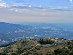
Uscendo dalla Porta si prosegue sul sentiero con una staccionata, questa è un Panoramic point dove si può ammirare da sinistra verso destra i Monti Lessini, il Corno D’aquilio, Fosse, Erbezzo; al centro la valle Lagarina il Monte Cimo e l’abitato di Spiazzi, la pianura padana, il lago di Garda e il Monte Baldo.
Panoramic point
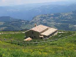
Al termine del sentiero teniamo la destra e attraversiamo il piazzale Giovanni Paolo II dove una strada o in alternativa gli scalini ci portano al Sanctuary of the Madonna della Corona:
Sanctuary of the Madonna della Corona
Suspended between heaven and earth, from this marvellous 16th century sanctuary you can have an extraordinary view of the Valdadige.
Return back on the same path, keep left and you arrive at the starting point in the small square of Spiazzi. 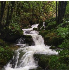
C11 – Spiazzi/Coalini/Omaner
A path between rural mountains courts, cherry trees and vineyards and the woods in the upper Tasso valley. View of Lake Garda and Monte Baldo.
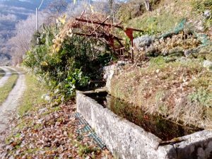
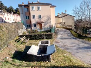
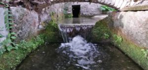
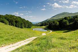
 Questo è un complesso di case dotate di lavatoio, da cui si gode una vista sulla vallata.
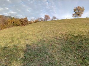
 Seguendo la strada si arriva ad un altro borgo chiamato Omaner caratterizzato per la coltivazione di ciliegie quindi, dopo l’abitato, teniamo la sinistra e scendiamo sulla strada che ci porta alla provinciale in prossimità del ponte Val della Scala, qui giriamo tutto a sinistra e proseguiamo nella valle del torrente con le sue cascatelle. Quindi si inizia una salita nel bosco che seguiamo fino al primo bivio dove si gira a destra e, proseguendo fino alla fine del sentiero si sbuca su un prato che, attraversato ci porta sulla stradina asfaltata.
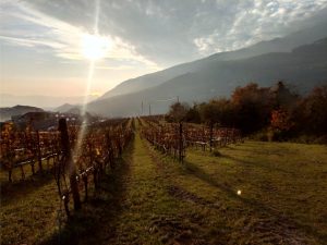
 Qui attraversiamo il sentiero tra i vigneti fino alla strada asfaltata, si prosegue a sinistra per arrivare sotto l’abitato detto Coltri:
 Continuing we pass in front of the parish church dedicated to Sant'Antonio da Padova then, after the monument to the fallen of all wars, on the right we find the route already taken at the start.
To be seen
The woods in the upper valley of the Tasso stream, the rural mountain resorts: Coliel, Coalini, Omaner and Coltri. A path between rural mountains courts, cherry trees and vineyards and the woods in the upper Tasso valley. View of Lake Garda and Monte Baldo. Si parte dalla piazzetta Don Luigi Vezzola quindi, attraversato il passaggio tra l’Osteria all’Italia e il ristorante a destra, scendendo una scalinata si raggiunge la strada Graziani e, tenendo la sinistra, dopo una decina di metri , si trova a destra una stradina che passa in mezzo alle abitazioni che porta alla località detta Villaggio. Seguiamo l’indicazione a destra per località Coliel, arrivati sulla strada asfaltata a sinistra dopo una decina di metri si imbocca la prima stradina che scende ripida sulla destra e, proseguendo, ci si trova ad attraversare il torrente, quindi si arriva in località Coalini:Coalini locality
Questo è un complesso di case dotate di lavatoio, da cui si gode una vista sulla vallata.
Wash house
Seguendo la strada si arriva ad un altro borgo chiamato Omaner caratterizzato per la coltivazione di ciliegie quindi, dopo l’abitato, teniamo la sinistra e scendiamo sulla strada che ci porta alla provinciale in prossimità del ponte Val della Scala, qui giriamo tutto a sinistra e proseguiamo nella valle del torrente con le sue cascatelle. Quindi si inizia una salita nel bosco che seguiamo fino al primo bivio dove si gira a destra e, proseguendo fino alla fine del sentiero si sbuca su un prato che, attraversato ci porta sulla stradina asfaltata.
Meadow
Qui attraversiamo il sentiero tra i vigneti fino alla strada asfaltata, si prosegue a sinistra per arrivare sotto l’abitato detto Coltri:
Vineyards
Coltri
Continuing we pass in front of the parish church dedicated to Sant'Antonio da Padova then, after the monument to the fallen of all wars, on the right we find the route already taken at the start. 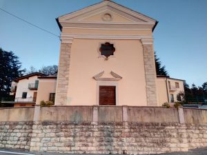
C12 – Spiazzi/Monte Croce/Stringari
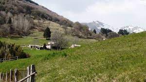
A journey through rural mountain courts, vineyards and woods. Excursion on Mount Croce. View of Lake Garda and Monte Baldo. The route crosses the territories of Spiazzi/Monte Croce/Stringari.
 Nel primo medioevo c’è chi ritiene località Croce fosse un Monastero, verso la fine dell’ottocento il centro del paese di Spiazzi coincideva con questa località detta la piccola Parigi, poiché dotata di osteria (al Lampione) un alloggio, affittacamere, una scuola elementare privata e anche una stazione delle guardie di Finanza la cui caserma era posta nella corte. Vi abitavano circa cento persone, alcune officine con una ventina di lavoratori di oggetti religiosi in osso. La corte era originariamente chiusa con quattro porte di protezione, “Porta Viveri” — Porta Lupi o Viandanti — Porta Latrine e Porta Morti dove si usciva per raggiungere il Cimitero di Ferrara. Si esce dal nucleo seguendo le indicazioni per l’hotel Stella Alpina, giunti in prossimità del termine del sentiero, teniamo la sinistra, saliamo verso la pineta sbucando su di un prato dove raggiungiamo il crinale del Monte Croce, da cui godere del panorama sul paese di Spiazzi e il Monte Baldo.
 Following the path on the ridge, continue north to the end of the meadow and, keeping to the left, return to the Croce district, then, on the right on the asphalted road, we find the path towards Villaggio. Following the sign Coliel once on the road we keep to the left and continuing to the next crossroads, we keep to the right until the crossroads that indicate Stringari. Stringari,
 scendiamo nel bosco seguendo la stradina e iniziamo la salita seguendo le indicazioni transitando al lato del vigneto fino a sbucare in prossimità della località Coltri e seguendo la strada asfaltata passeremo davanti alla Parish Church of Sant’Antonio da Padova per poi raggiungere il punto di partenza di Spiazzi.
To be seen
Mount Croce, the chestnut woods and the rural mountain resorts: Coliel, Stringari and Coltri. Un percorso tra corti rurali di montagna, vigneti e boschi. Escursione sul monte Croce. Vista sul Lago di Garda e sul Monte Baldo. Il percorso attraversa i territori di Spiazzi/Monte Croce/Stringari. Si parte dalla piazzetta Don Luigi Vezzola, imboccando la strada che sale in località Croce, il nucleo storico più antico di Spiazzi.Spiazzi
Nel primo medioevo c’è chi ritiene località Croce fosse un Monastero, verso la fine dell’ottocento il centro del paese di Spiazzi coincideva con questa località detta la piccola Parigi, poiché dotata di osteria (al Lampione) un alloggio, affittacamere, una scuola elementare privata e anche una stazione delle guardie di Finanza la cui caserma era posta nella corte. Vi abitavano circa cento persone, alcune officine con una ventina di lavoratori di oggetti religiosi in osso. La corte era originariamente chiusa con quattro porte di protezione, “Porta Viveri” — Porta Lupi o Viandanti — Porta Latrine e Porta Morti dove si usciva per raggiungere il Cimitero di Ferrara. Si esce dal nucleo seguendo le indicazioni per l’hotel Stella Alpina, giunti in prossimità del termine del sentiero, teniamo la sinistra, saliamo verso la pineta sbucando su di un prato dove raggiungiamo il crinale del Monte Croce, da cui godere del panorama sul paese di Spiazzi e il Monte Baldo.
Monte Croce
Following the path on the ridge, continue north to the end of the meadow and, keeping to the left, return to the Croce district, then, on the right on the asphalted road, we find the path towards Villaggio. Following the sign Coliel once on the road we keep to the left and continuing to the next crossroads, we keep to the right until the crossroads that indicate Stringari. Stringari,
scendiamo nel bosco seguendo la stradina e iniziamo la salita seguendo le indicazioni transitando al lato del vigneto fino a sbucare in prossimità della località Coltri e seguendo la strada asfaltata passeremo davanti alla Parish Church of Sant’Antonio da Padova per poi raggiungere il punto di partenza di Spiazzi.
Coltri
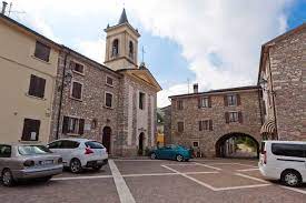
Parish Church of Sant’Antonio da Padova
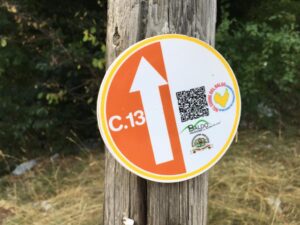
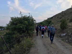
C13 – Baldo Crossing
You start from the cemetery of Caprino Veronese, turn left and at the roundabout to the right take the cycle path next to the supermarket then, arrived in via I Maggio, continue to the intersection and then turn right. Continue along the sports area then, up to the capital and here you turn sharply to the left. At the intersection with the provincial road, turn right and then left, towards Caiar after a few tens of meters, an opening in the wall reveals a suggestive washhouse.
 You reach Malga Ime. After passing the hut, go up until you reach the plain of Malga Valfredda.
 Keeping the main road you arrive at the Colonei di Caprino.
 Continue on a pastoral road to the panoramic Malga Colonei di Pesina to reach Malga Zocchi through a beech forest.
 Continue to Due Pozze then turn left on the road to Naole.
 From the parking lot of two Pozze, go down for a few kilometers to the intersection with the provincial road along the road to Prada, turn left until you reach the town of Lumini.
 Here you keep left towards Caprino V.se and, after a few kilometers, in the locality of Peagne, turn right into via Peagne di Sotto. The road becomes a path and upon reaching the asphalt, keep to the right towards the town of Rubiana.
 Once arrived at the church of St. Eurosia, keep left and left again to get to the provincial road. At the intersection, continue left, pass in front of Palazzo Carlotti and then, continuing, to the starting point.
Cometti washhouse
Once in the town of Caiar, turn right and, passing the pink fountain, continue on the path that leads to the locality of San Michele. Climb up to the hamlet of Vilmezzano where the church of the Beata vergine del Carmelo is located, continue in the locality of Renzon and reach the locality of Braga where the church of the immaculate is located and where you can admire a spectacular panorama. Cross the town and continue for a few kilometers to Pradonego, then, after crossing the beech forest.
Padronego and the beech forest
You reach Malga Ime. After passing the hut, go up until you reach the plain of Malga Valfredda.
Malga Ime
Malga Valfredda Crocetta
Keeping the main road you arrive at the Colonei di Caprino.
Malga Colonei di Caprino
Continue on a pastoral road to the panoramic Malga Colonei di Pesina to reach Malga Zocchi through a beech forest.
Malga Zocchi
Continue to Due Pozze then turn left on the road to Naole.
Due Pozze
From the parking lot of two Pozze, go down for a few kilometers to the intersection with the provincial road along the road to Prada, turn left until you reach the town of Lumini.
Lumini
Here you keep left towards Caprino V.se and, after a few kilometers, in the locality of Peagne, turn right into via Peagne di Sotto. The road becomes a path and upon reaching the asphalt, keep to the right towards the town of Rubiana.
Rubiana
Once arrived at the church of St. Eurosia, keep left and left again to get to the provincial road. At the intersection, continue left, pass in front of Palazzo Carlotti and then, continuing, to the starting point.
C14 – Caprino/Ceredello
In the plain of Caprino Veronese, a wide view from Monte Baldo to Monte Moscal, the profile of the town of Pesina and the passing of the seasons in traditional crops.
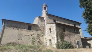
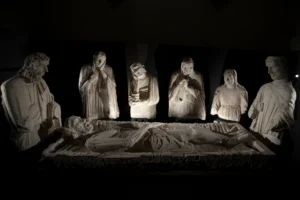
 The route runs alongside the 13th century Romanesque church of the Holy Sepulchre, which went through a series of vicissitudes but is now quite well preserved. Originally it housed the sculptural cycle of the "Lamentation over the Dead Christ", an important work now exhibited in the museum of Palazzo Carlotti in Caprino.
 The cycle path leads to Ceredello: a small hamlet, once autonomous and today a fraction of the Municipality of Caprino Veronese. Its presence is attested at least from the mid-twelfth century, when at the end of the century the considerable properties that the Chapter of the cathedral of Verona had in place began to be documented. From the route you have a broad view of the plain of Caprino Veronese which delimits the ridge of Monte Baldo to the south, visible to the north. Mount Belpo.
 The route reaches the Ceredello playground and from here you go back to reach the starting point.
To be seen
Beginning of the ridge of Monte Baldo, Monte Belpo, Monte Bandiera, Monte Lenzino, Monte Luppia, plain of Caprino Veronese. Quiet flat walk, suitable for handicapped people. It starts from the parking lot of the Caprino Veronese cemetery, from here you take the cycle path that runs along the south side of the cemetery enclosure
The route runs alongside the 13th century Romanesque church of the Holy Sepulchre, which went through a series of vicissitudes but is now quite well preserved. Originally it housed the sculptural cycle of the "Lamentation over the Dead Christ", an important work now exhibited in the museum of Palazzo Carlotti in Caprino.
View from the Ceredello cycle path
The cycle path leads to Ceredello: a small hamlet, once autonomous and today a fraction of the Municipality of Caprino Veronese. Its presence is attested at least from the mid-twelfth century, when at the end of the century the considerable properties that the Chapter of the cathedral of Verona had in place began to be documented. From the route you have a broad view of the plain of Caprino Veronese which delimits the ridge of Monte Baldo to the south, visible to the north. Mount Belpo.
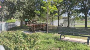
Ceredello playground
The route reaches the Ceredello playground and from here you go back to reach the starting point. 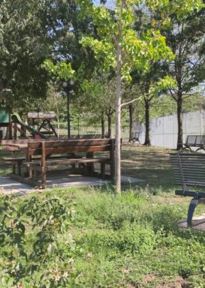
C15 – Ceredello/Bran
Beginning of the ridge of Monte Baldo, Monte Belpo, Monte Bandiera, Monte Lenzino, Monte Luppia, plain of Caprino Veronese.
It starts from the car park of the Ceredello playground. Ceredello is a small hamlet, once autonomous and today a fraction of the Municipality of Caprino Veronese. Its presence is attested at least from the mid-twelfth century, when at the end of the century the considerable properties that the Chapter of the cathedral of Verona had in place began to be documented. Take the first right and then turn right again at the intersection, on the cycle-pedestrian path. From here you have a broad view of the plain of Caprino Veronese which delimits the ridge of Monte Baldo to the south, visible to the north. Mount Belpo.
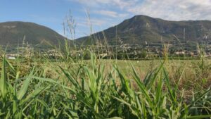
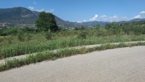
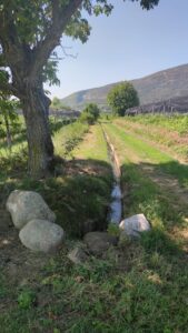
 Take the cycle path that crosses the agricultural territory of the plain of Caprino, with cultivation of orchards, vines and pastures. On the right, during the course of the walk, a suggestive view of the mountain and the plain brings peace and a sense of peace, being immersed in nature. Immediately afterwards, to reinforce these sensations, there is a tree near a stream with lots of stones that seem to be a dam to the stream itself.
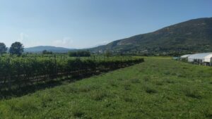
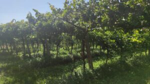
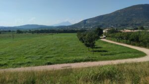
 A destra si scorgono i monti Bandiera, Lenzino e Luppia che si affacciano sul Lago di Garda. La piana offre un paesaggio agricolo dove prevale la coltivazione della vite, in particolare per la produzione del vino Bardolino.
Al termine del sentiero si svolta a sinistra e si segue la strada principale che aggira Corte Bran. Edificata intorno al ‘400, rappresentata sugli arazzi visibili ai Musei Vaticani, Corte Bran costituiva anch’essa proprietà della Curia di Verona. Si tiene la sinistra e si imbocca la pista ciclabile che corre a fianco di un terreno boschivo, fino ad arrivare al Parco Giochi di Ceredello, e si ritorna al punto di partenza.
A destra si scorgono i monti Bandiera, Lenzino e Luppia che si affacciano sul Lago di Garda. La piana offre un paesaggio agricolo dove prevale la coltivazione della vite, in particolare per la produzione del vino Bardolino.
Al termine del sentiero si svolta a sinistra e si segue la strada principale che aggira Corte Bran. Edificata intorno al ‘400, rappresentata sugli arazzi visibili ai Musei Vaticani, Corte Bran costituiva anch’essa proprietà della Curia di Verona. Si tiene la sinistra e si imbocca la pista ciclabile che corre a fianco di un terreno boschivo, fino ad arrivare al Parco Giochi di Ceredello, e si ritorna al punto di partenza.
Ceredello playground
Take the cycle path that crosses the agricultural territory of the plain of Caprino, with cultivation of orchards, vines and pastures. On the right, during the course of the walk, a suggestive view of the mountain and the plain brings peace and a sense of peace, being immersed in nature. Immediately afterwards, to reinforce these sensations, there is a tree near a stream with lots of stones that seem to be a dam to the stream itself.
View from the cycle path
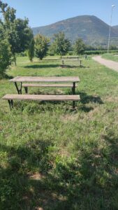
Picnic area
A destra si scorgono i monti Bandiera, Lenzino e Luppia che si affacciano sul Lago di Garda. La piana offre un paesaggio agricolo dove prevale la coltivazione della vite, in particolare per la produzione del vino Bardolino.
Al termine del sentiero si svolta a sinistra e si segue la strada principale che aggira Corte Bran. Edificata intorno al ‘400, rappresentata sugli arazzi visibili ai Musei Vaticani, Corte Bran costituiva anch’essa proprietà della Curia di Verona. Si tiene la sinistra e si imbocca la pista ciclabile che corre a fianco di un terreno boschivo, fino ad arrivare al Parco Giochi di Ceredello, e si ritorna al punto di partenza.
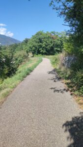
Path view