

Overview
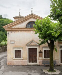
Departing from the parking lot by the Caprino Veronese cemetery, you take the cycle path that runs along the south side of the cemetery enclosure. The cycle path crosses the nucleus of Ceredello, important for the church of Santa Cristina. There is documented evidence that the Church dates back to the year 1221.
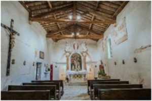
Oratory of Santa Cristina
You arrive at the artisan area called Bran, at the end of this area you turn right along the road called Circonvallazione-Bran then, continuing on via San Rocco, you reach the church of the same name.
Oratory of San Rocco di Pesina
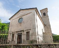
The Oratory of San Rocco has been documented since at least 1523, continuing to the right on via Nogarole, you reach the town of Pesina. Here, just before the parish church of San Gallo, turn left and take via Castello. The route continues uphill until you reach the provincial via Lumini, here turn right, after a few hundred meters keep left to enter the hamlet of Rubiana where you will find the church of Sant'Eurosia.
Oratory of Sant’Eurosia
The road joines the main road and immediately afterwards on the left, take the dirt path that leads to Ca’ Forcon.
The path at some point becomes cobbled because you enter the core of Gaon.
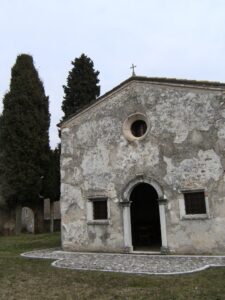
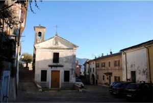
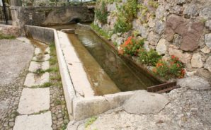
Gaon: Oratory of San Rocco and washhouse
Before entering the historic town with its ancient wash houses, turn left onto a steep road that leads through the area called Terre Rosse to reach Vilmezzano.
Vilmezzano: Church of Beata Vergine del Carmelo
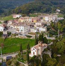
The church of the Beata Vergine del Carmelo was recognised to be from the late 1400s. Continue to the left of the church along the paved road until you reach the intersection with the capital. From here, keeping to the left and shortly after taking the road to the right, you reach the center of Braga with the church of the Immaculate Conception (6), from which you can enjoy a beautiful view of the Morainic Amphitheater and Lake Garda.
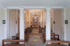
Braga: panorama and Church of Immacolata
Continue climbing for a few hundred meters until you find a path in the woods on the right. From here the path begins to descend, passing through the towns of Omaner and Coalini, then it enters the woods again until it comes out on the provincial road. Keep left and after a few hundred meters, on the right, take another path that leads to the hamlets of Porcino.
Panorama


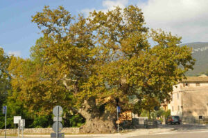
Further on you will reach Platano with the tree that gives it its name.
Continuing after a few hundred meters, take the path on the right, then when you reach the town, turn left. After passing the sports field area, turn left at the roundabout and that takes you back to the starting point.
The path of the monks
To be seen
An association, such as the present one, which boasts the expression pro loco, already in the header explicitly declares, without reservations, that it intends to operate exclusively for the benefit of the local community of Caprino Veronese: alien to ulterior motives, private interests. pro loco, già nell’intestazione dichiara in modo esplicito, senza riserve, di intendere operare esclusivamente a beneficio della locale comunità di Caprino Veronese: aliena da secondi fini, da interessi privati. Espressione comune di un associazionismo vitale che, nelle varie connotazioni, caratterizza le nostre generose popolazioni, si identifica, però, per l’attenzione, in particolare, riservata alla valorizzazione, alla promozione del territorio caprinese nei suoi aspetti paesaggistici, ambientali, storico-artistici. Così la Pro Loco si fa attiva protagonista di innumerevoli iniziative indirizzate alla conservazione e alla valorizzazione di un patrimonio che si vuole anche condividere e fra queste si pone il progetto “ I cammini della Corona”.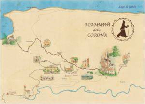
WAY OF THE MONKS
From the Hermitage of San Giorgio to the Sanctuary of the Madonna della Corona
Presentation
Il progetto “I cammini della Corona” nasce dalla dichiarazione del Ministero dei Beni Culturali e Turismo che ha proclamato il 2019 come “Anno nazionale del turismo lento”. Il turismo lento è un turismo di nicchia che si propone quale alternativa al turismo “tutto e subito” o “mordi e fuggi” perché presuppone il camminare con ritmi che consentono di guardarsi intorno, concedendosi il tempo di osservare, di assaporare, di ammirare e di vivere l’esperienza di un luogo “ascoltandone” le storie. La ricchezza storica, culturale, religiosa ed anche enogastronomica del nostro territorio può in tal modo essere messa a disposizione di chi intende vivere un’esperienza “intima” (anche se non necessariamente solo) e crede che il camminare a “passo lento” sia una filosofia in cui le gambe sono sì il veicolo ma è la persona intera che entra in gioco; il cammino stesso ci procura un senso di libertà che è anche un guardare (non solo un vedere distrattamente e velocemente), uno scoprire un territorio, un rendersi conto di quello che è o è stato, un relazionarsi con le persone e le “cose” che si incontrano e si scoprono. Il progetto “I cammini della Corona” è impostato appunto sul paradigma del “camminare lento” ed è imperniato su due caposaldi del nostro territorio: l’Eremo camaldolese di Bardolino ed il Sanctuary of the Madonna della Corona. Abbiamo pensato quindi a vari itinerari che, partendo da direzioni diverse (l’alto lago di Garda, il baso lago, le colline di Rivoli, Ferrara di monte Baldo), arrivino a questi due punti nevralgici del territorio con una serie di varianti che spesso, intersecandosi tra loro, permettono al viandante di scegliere il proprio “cammino”. Oltre agli splendidi paesaggi naturali, che lo accompagnano, il “camminatore” entra in relazione con un patrimonio storico, artistico, spirituale, dato dalle numerose chiesette medioevali, dai capitelli, dalle croci votive, ma anche dai palazzi, dalle ville, dai monumenti, dalle fontane e dai lavatoi: da tutto ciò che i nostri antenati hanno costruito e ci hanno lasciato in eredità perché, appunto, ne potessimo “godere” con coscienza e responsabilità. Nei più o meno lunghi percorsi, infine, non possono mancare dei momenti di sosta e luoghi, che abbiamo debitamente provveduto ad individuare e a segnalare, dove sostare e riposare; rifocillarsi, gustando i prodotti tipici, per “assaporare” il nostro splendido territorio, e, magari, trascorrere anche la notte. Walter Pericolosi Preface Quello cosiddetto religioso è a tutt’oggi il turismo più diffuso che muove su tutta la Terra masse di fedeli di ogni confessione. Si tratta di un fenomeno generale, trasversale che non riguarda soltanto l’universo cristiano, in particolare cattolico, e trova le sue motivazioni, ben oltre l’aspetto prettamente turistico del viaggiare, del visitare-conoscere, in una necessità, dall’uomo sempre avvertita, di un soccorso soprannaturale nei pericoli, nelle calamità che il semplice fatto di esistere comporta; di un conforto ai mali, alle sofferenze dell’anima e del corpo. Così fin dalle origini del Cristianesimo, magari anche sollecitato dalle narrazioni agiografiche, si assistette ad un flusso di devoti che si mettevano in viaggio per recarsi sui luoghi dove si conservavano le sacre reliquie o le spoglie tumulate dei santi. A Verona, per restare in un ambito a noi prossimo, fin dagli inizi del V secolo il vescovo Petronio scriveva di come al sepolcro di Zeno, il santo patrono della città, convenisse una folla di devoti, di afflitti nel corpo o nell’anima a implorarne l’ausilio e di come egli provvedesse prodigiosamente a guarire gli infermi, a mondare gli animi dal peccato, restituendo la gioia della purezza. Ovviamente fin d’allora non poteva essere ignorato, aspetto di certo profano ma di sostanza, l’opportunità di profitto che tali flussi di devoti comportava. Ricorderò, dicendo di una santa pure a noi vicina, l’Adelaide prigioniera sulla rocca di Garda, che, una volta accoltene le spoglie mortali, i monaci del monastero dei Santi Pietro e Paolo, a Seltz in Alsazia, provvidero prontamente a redigere un Liber miraculorom, dove si narrava dei miracoli dalla santa compiuti: un testo proprio ad uso dei pellegrini, ad incentivarne la devozione, le visite e… le donazioni. In tempi meno lontani è nota a tutti la diffusione del culto per la Vergine ed il proliferare di venerati santuari, quali, sempre in un ambito locale, quelli della Madonna della Corona a Spiazzi, della Madonna del Frassino a Peschiera, della Beata Vergine del Soccorso a Marciaga. In questi convenivano non solo singoli devoti, ma persino intere comunità, come si sa della gente di Bardolino che nel 1665 si era recata processionalmente al santuario della Corona ad invocare la pioggia. Ottenuta la grazia, un celebre quadro venne fatto dipingere per ex voto a tramandarne la memoria. E mantenere il voto era un adempimento così grave che nemmeno la morte poteva sciogliere. Così in testamenti del Quattro-Cinquecento non sono infrequenti disposizioni da parte dei testatori a che i propri eredi siano tenuti, personalmente o tramite dei sostituti, a soddisfare il voto di un pellegrinaggio al santuario della Madonna di Loreto, alla basilica di Sant’Antonio di Padova, ma pure alla chiesa della Madonna della Corona che in vita non avevano potuto mantenere. E oggi, nonostante il distacco dai valori dello spirito, ci tenta ancora il farci pellegrini e cercare consolazione ai nostri giorni, quando questi ci assalgono cupi e minacciosi. Giuliano SalaThe sanctuary of the Madonna della Corona
Hermitage of San Giorgio di Bardolino
 La Congregazione camaldolese di Monte Corona, a seguito di donazioni, avviò sul monte San Giorgio di Bardolino la fondazione di un eremo che, ultimato nel 1665, venne nel 1672 eretto in priorato. Soppresso nel 1810 in causa delle disposizioni napoleoniche sugli ordini monastici, il complesso dell’eremo fu acquistato dal conte Danese Burri che fece abbattere le cellette di mezzo, mentre le laterali furono adibite ad abitazione dei contadini, impiegati nella lavorazione dei terreni messi a coltura. Nel 1885 la Congregazione lo riacquistò dagli eredi insieme a tutto il monte San Giorgio e vi inviò nuovamente dei monaci. Questi, tranne che per una breve parentesi fra gli anni 1962-1972, vi rimasero fino a quando nel 1993 a loro subentrarono i monaci camaldolesi di Toscana ai quali l’eremo era stato concesso in comodato dal vescovo di Verona. La chiesa monacale, costruita in stile moderatamente barocco sulle rovine di un antico oratorio, è a un’unica navata con sacrestia e tre cappelle laterali; pregevole il coro con 24 stalli in noce ad accogliere i frati nella recita dell’Ufficio Divino giornaliero. Fra i dipinti, che ornano gli altari, ricordiamo le pale con le raffigurazioni di San Giorgio e il drago, di autore ignoto e in passato erroneamente attribuita a Giovanni Tedeschi, di San Romualdo, opera di Palma il Giovane, e della Vergine fra sant’Anna e san Gioacchino di Francesco Paglia.
Costermano German military cemetery
Sul colle Le Guardie, in località Baesse di Costermano, si stende in uno scenario di verde punteggiato d’erica il Cimitero ossario realizzato fra gli anni 1956-1967. Qui furono raccolte le salme di oltre 22.000 soldati tedeschi, caduti negli ultimi anni della Seconda guerra mondiale, tratte da cimiteri militari e occasionali luoghi di sepoltura dell’Italia settentrionale. I filari ordinati delle lapidi ne segnano le sepolture in un monito contro la guerra e anelito di pace. Recentemente il comune di Costermano sul Garda ha avviato il progetto per la realizzazione di un parco contiguo, significativamente denominato Parco dell’amicizia dei popoli.
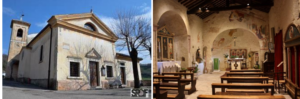
Oratory of San Rocco di Pesina
The oratory of San Rocco, which overlooks the south side of the road that leads from Costermano to Pesina, has been documented since at least 1523 with the function of welcoming local people to the celebration of mass, especially farmers in the summer. Over time it underwent various renovations up to its present appearance with a neoclassical façade, a single hall, equipped with two side chapels, and a quadrangular apse, where the seventeenth-century altarpiece by Giovanni Ceschini is kept with the depiction of the titular saint; an elegant raised choir leans against the counter-façade. On the outside of the east wall rises the quadrangular bell tower, surmounted by an octagonal drum and a pyramidal brick cusp, with on the top a very ruined statuette that would have depicted San Rocco.
Oratory of Sant'Antonio abbot of Boi
The oratory of Sant'Antonio, now deconsecrated and used for profane uses, is documented in a will of 1441 in which a certain Fazio of the late Gisalberto da Pesina left four ducats for the purchase of a missal to be used in the church. The locality in which it is located also takes its name from the presence of this, mentioned in the papers at least since 1476. In the 16th century it was known to belong to the priory of Sant'Antonio della Ghiara in Verona and therefore to the Bishop's Seminary, after it had been granted the commendation of the ancient priory. Oratory and pertinent land thus remained the property of the seminary until in 1867, as a result of the so-called subversive laws of the ecclesiastical axis, they were confiscated by the Royal Property. Therefore, through public auction, they were put up for sale and purchased by private individuals; today it belongs to the Gentili family who use it for the winery.
Oratory of Santa Maria della Mercede di Boi
The oratory of Santa Maria della Mercede, formerly dedicated to San Giovanni, is documented by the pastoral visits of the 16th century, but the presence in the past inside of the famous polyptych attributed to the painter Altichiero, now in the Museum of Castelvecchio, suggests existence since at least the late fourteenth century. The current building in neo-Gothic style is the result of a radical restructuring carried out around the mid-nineteenth century by the Cattarinetti family, when the oratory also began to be known with the title of Santa Maria della Mercede, granted to it in honor of the Virgin by the community of Boi for having been preserved from the cholera contagion in 1836.
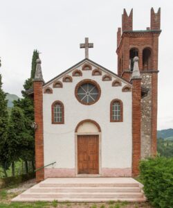
Oratory of Santa Eurosia of Rubiana
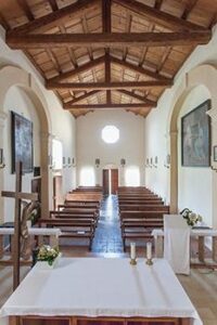
The oratory of Sant'Eurosia, protector from storms and also from droughts, was built in the years 1737-1742 on the initiative of the heads of families from the local districts of Balconi, Dosso de' Tononi and Guìn. In 1806, due to the Napoleonic decrees on the suppression of public oratories, the church was closed and confiscated by the Royal State Property Office, but was immediately reopened for worship by the locals. The neoclassical style building with an elegant gabled façade has a single hall, ending in the pentagonal apse, where an eighteenth-century canvas is preserved, depicting. Il martirio di sant’Eurosia.
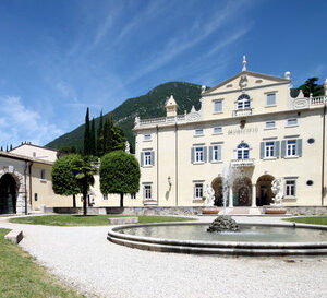
Palazzo Carlotti and the sculptural group of "The Lamentation"
La Congregazione camaldolese di Monte Corona, a seguito di donazioni, avviò sul monte San Giorgio di Bardolino la fondazione di un eremo che, ultimato nel 1665, venne nel 1672 eretto in priorato. Soppresso nel 1810 in causa delle disposizioni napoleoniche sugli ordini monastici, il complesso dell’eremo fu acquistato dal conte Danese Burri che fece abbattere le cellette di mezzo, mentre le laterali furono adibite ad abitazione dei contadini, impiegati nella lavorazione dei terreni messi a coltura. Nel 1885 la Congregazione lo riacquistò dagli eredi insieme a tutto il monte San Giorgio e vi inviò nuovamente dei monaci. Questi, tranne che per una breve parentesi fra gli anni 1962-1972, vi rimasero fino a quando nel 1993 a loro subentrarono i monaci camaldolesi di Toscana ai quali l’eremo era stato concesso in comodato dal vescovo di Verona. La chiesa monacale, costruita in stile moderatamente barocco sulle rovine di un antico oratorio, è a un’unica navata con sacrestia e tre cappelle laterali; pregevole il coro con 24 stalli in noce ad accogliere i frati nella recita dell’Ufficio Divino giornaliero. Fra i dipinti, che ornano gli altari, ricordiamo le pale con le raffigurazioni di San Giorgio e il drago, di autore ignoto e in passato erroneamente attribuita a Giovanni Tedeschi, di San Romualdo, opera di Palma il Giovane, e della Vergine fra sant’Anna e san Gioacchino di Francesco Paglia.
Costermano German military cemetery
Sul colle Le Guardie, in località Baesse di Costermano, si stende in uno scenario di verde punteggiato d’erica il Cimitero ossario realizzato fra gli anni 1956-1967. Qui furono raccolte le salme di oltre 22.000 soldati tedeschi, caduti negli ultimi anni della Seconda guerra mondiale, tratte da cimiteri militari e occasionali luoghi di sepoltura dell’Italia settentrionale. I filari ordinati delle lapidi ne segnano le sepolture in un monito contro la guerra e anelito di pace. Recentemente il comune di Costermano sul Garda ha avviato il progetto per la realizzazione di un parco contiguo, significativamente denominato Parco dell’amicizia dei popoli.
Oratory of San Rocco di Pesina
The oratory of San Rocco, which overlooks the south side of the road that leads from Costermano to Pesina, has been documented since at least 1523 with the function of welcoming local people to the celebration of mass, especially farmers in the summer. Over time it underwent various renovations up to its present appearance with a neoclassical façade, a single hall, equipped with two side chapels, and a quadrangular apse, where the seventeenth-century altarpiece by Giovanni Ceschini is kept with the depiction of the titular saint; an elegant raised choir leans against the counter-façade. On the outside of the east wall rises the quadrangular bell tower, surmounted by an octagonal drum and a pyramidal brick cusp, with on the top a very ruined statuette that would have depicted San Rocco.
Oratory of Sant'Antonio abbot of Boi
The oratory of Sant'Antonio, now deconsecrated and used for profane uses, is documented in a will of 1441 in which a certain Fazio of the late Gisalberto da Pesina left four ducats for the purchase of a missal to be used in the church. The locality in which it is located also takes its name from the presence of this, mentioned in the papers at least since 1476. In the 16th century it was known to belong to the priory of Sant'Antonio della Ghiara in Verona and therefore to the Bishop's Seminary, after it had been granted the commendation of the ancient priory. Oratory and pertinent land thus remained the property of the seminary until in 1867, as a result of the so-called subversive laws of the ecclesiastical axis, they were confiscated by the Royal Property. Therefore, through public auction, they were put up for sale and purchased by private individuals; today it belongs to the Gentili family who use it for the winery.
Oratory of Santa Maria della Mercede di Boi
The oratory of Santa Maria della Mercede, formerly dedicated to San Giovanni, is documented by the pastoral visits of the 16th century, but the presence in the past inside of the famous polyptych attributed to the painter Altichiero, now in the Museum of Castelvecchio, suggests existence since at least the late fourteenth century. The current building in neo-Gothic style is the result of a radical restructuring carried out around the mid-nineteenth century by the Cattarinetti family, when the oratory also began to be known with the title of Santa Maria della Mercede, granted to it in honor of the Virgin by the community of Boi for having been preserved from the cholera contagion in 1836.
Oratory of Santa Eurosia of Rubiana
The oratory of Sant'Eurosia, protector from storms and also from droughts, was built in the years 1737-1742 on the initiative of the heads of families from the local districts of Balconi, Dosso de' Tononi and Guìn. In 1806, due to the Napoleonic decrees on the suppression of public oratories, the church was closed and confiscated by the Royal State Property Office, but was immediately reopened for worship by the locals. The neoclassical style building with an elegant gabled façade has a single hall, ending in the pentagonal apse, where an eighteenth-century canvas is preserved, depicting. Il martirio di sant’Eurosia.
Palazzo Carlotti and the sculptural group of "The Lamentation"
 Odierna sede municipale del comune di Caprino Veronese, il palazzo venne edificato su un edificio rurale quattrocentesco dalla nobile famiglia dei Vimercati che, procedendo, poi, ad un ampliamento dell’edificio, ne rimosse ogni segno di un passato connesso con l’attività agricola, in funzione di una magnificazione del decoro aristocratico. Nel 1601 il palazzo venne acquistato dal canonico Marcello Carlotti che ne lasciò immutata l’architettura, occupandosi soltanto del decoro pittorico. Solo nei primi anni del ‘700 vennero apportate le modifiche che ne determinarono l’aspetto odierno con l’aggiunta del frontone, della balaustra ai lati e dell’ala sinistra per ragioni di simmetria. L’intento autocelebrativo dei proprietari, che alla magnificenza del palazzo affidano l’espressione del loro prestigio, predomina ormai e il blasone di famiglia, che spicca nel timpano del frontone a sormontare il corpo centrale, ne è chiaro segno. Più tardi, ma sempre nel ‘700, verrà costruito il porticato che si apre ad occidente sulla corte.
All’interno, oltre alle splendide sale, fra le quali emerge l’incantevole “Sala dei Sogni”, interamente affrescata da Paolo Ligozzi e bottega nel primo ‘600 con “grottesche” e motivi d’ispirazione biblica, classica, ma anche contemporanea, è possibile ammirare in tutta la sua bellezza il gruppo scultoreo di metà ’300, ivi collocato, dall’originaria sede presso la chiesa del Santo Sepolcro, dopo le operazioni di restauro da parte dell’opificio delle Pietre dure di Firenze. Il gruppo, attribuito allo scultore Rigino di Enrico, noto come Il compianto, rappresenta più propriamente la deposizione di Gesù nel sepolcro ad opera di Giuseppe d’Arimatea e di Nicodemo assistiti dalle pie donne e dall’apostolo Giovanni. Diversamente da altre opere del tempo di simile soggetto, il gruppo denota nei lineamenti di Gesù defunto e di vari personaggi un dolore, un’angoscia inconsolabili; la maschera orribile della morte, non più cristianamente accettata con pacata rassegnazione come l’inizio di una nuova vita, sic moriar ut vivam, ma sofferta ora quale straziante distacco: una visione che pur nella religiosità del tema assume i toni di un sentire ormai laico che precorre i tempi.
Oratory of San Martino in the Caprinese district of San Martino
L’oratorio di San Martino presso l’omonima contrada è documentato almeno dagli inizi del secolo XIII quale cappella della pieve di Caprino, come si evincerà dalle visite pastorali del ‘500; a partire, poi, dal 1568 andò soggetto alla neo costituitasi parrocchia di Pazzon. La chiesa, con annesso in passato anche un piccolo cimitero, servì per secoli, nonostante i giuspatronati dei nobili Brenzoni e Montagna sui rispettivi altari, alla popolazione della contrada che vi conveniva ad assistere alla Messa finché in tempi moderni decadde a semplice oratorio e oggigiorno vi si celebra solo occasionalmente. L’edificio, pur privato della facciata con l’addossarvisi nel ‘500 della casa, all’epoca, costruita ad uso del cappellano, mostra nella navata e nell’abside semicircolare chiari segni dell’originaria costruzione romanica; successivamente, sul finire del ‘400 venne aggiunta sul lato di settentrione la cappella a contenere l’altare eretto dal nobile Antonio Montagna; quindi nel secolo successivo vi si appoggiò sul lato di meridione un portico, sorretto da tre pilastri, dal quale si ebbe accesso alla chiesa tramite due ingressi. Nel ‘700 fu eretto il campanile. All’interno spiccano sul catino e l’arcata absidali gli affreschi del primo ‘400 con le raffigurazioni di Cristo in mandorla e de L’annunciazione; sull’esterno altri affreschi del primo ‘300 riportano le immagini di San Cristoforo e di San Martino e il mendicante. Quindi un ulteriore dipinto votivo, eseguito questo nel 1512 su committenza della famiglia Montagna, raffigura La Madonna in trono col Bambino fra i santi Sebastiano e Rocco, invocati a protezione dall’imperversare della peste. Di pregio si conservano all’interno la pala d’altare, di fine secolo XV, della cappella Montagna con I santi Francesco, Antonio di Padova e Agapito e il paliotto dell’altare maggiore, fatto eseguire da Alessandro Brenzoni nel 1513, con I santi Caterina d’Alessandria, Martino e Lucia.
Oratory of San Martino (Video)
Oratorio di San Rocco di Gaon
Following the plague epidemic of 1511, the inhabitants of the district matured the intention of erecting an oratory in honor of San Rocco, protector from the disease. However, the vow went into oblivion and only the raging plague again in the summer of 1630 induced them to carry it out. In use by the Gaon community at least since 1634, it had two successive extensions over time, at the end of the 17th century and in the first decade of the last century, which resulted in an elongation towards the east; the elegant gabled façade in classic style remains from the original building. In a niche, carved into the tympanum of the pediment, there is a seventeenth-century stone statuette, depicting the titular saint.
Oratory of the Blessed Virgin of Carmel in Vilmezzano
Fin dal tardo ‘400 si sa dell’esistenza di un oratorio dedicato a san Bernardino da Siena; quindi nel secolo successivo il titolo fu mutato in onore della Madonna del Carmelo la cui statua veniva portata processionalmente fino al santuario della Beata Vergine del Soccorso a Marciaga. Nel 1703 la chiesa fu devastata dalle soldataglie franco-spagnole nel corso della guerra di successione di Spagna, ma fu prontamente ristrutturata e, in particolare, dotata di un nuovo altare in stile barocco, dove ora sta la pala con Madonna con Bambino fra angeli e i santi Sebastiano, Antonio di Padova, Bernardino e Rocco, Sebastiano e Antonio di Padova, opera del 1723 di autore ignoto. Alienato al Regio Demanio in seguito alle soppressioni napoleoniche, l’oratorio venne poi restituito al culto. Decorata nel 1914 dagli affreschi in stile liberty del pittore gardesano Antonio Pimazzoni, la chiesa conserva le belle linee della ristrutturazione settecentesca con facciata timpanata, unica aula, cappella laterale e abside poligonale. La vecchia sacrestia addossata sul lato sud funge oggi da cappella invernale.
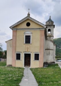
Oratory of the Immaculate Conception of Braga
The oratory of the Immaculate Conception, perched on a rocky outcrop near the district of Braga, was built in neo-Gothic style in 1938 to meet the spiritual needs of the locals, disadvantaged by the distance from the parish church of Pazzon. Struck by lightning in 1975, the church was promptly restored and reopened for worship in August 1976.
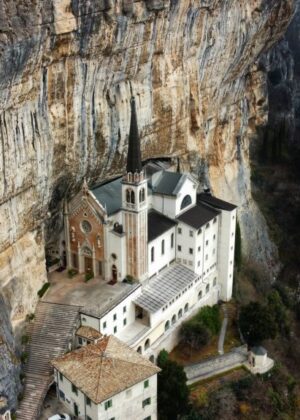
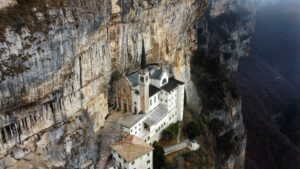
Sanctuary of the Madonna della Corona
Già nel tardo secolo XII degli eremiti avrebbero fondato alla Corona di Monte Baldo una prima chiesetta, documentata almeno dal 1203 come dipendente dal monastero veronese di San Zeno, sulla quale si sarebbe sviluppato il santuario mariano. Dal 1437 i possedimenti in area montebaldina del monastero di San Zeno risultano acquisiti dai Cavalieri di Rodi, in seguito di Malta, per cui se ne desume che anche la chiesa della Corona passasse alle dipendenze dell’ordine. La dipendenza perdurerà quindi ininterrottamente sino alla fine del Settecento e in tale tempo si avranno le varie ristrutturazioni della chiesa, le fabbriche degli edifici annessi, i lavori a facilitare l’accesso e un impulso al culto per la sacra immagine della Madonna della Pietà, presso il santuario presente almeno dal terzo decennio del ‘500.
Arresasi Malta alla flotta francese nel corso delle guerre napoleoniche, il santuario fu acquisito nel 1806 dall’episcopio veronese e con decreto del 12 giugno 1812 il vescovo Innocenzo Liruti lo assegnò alla parrocchia di Ferrara di Montebaldo. Questa ne mantenne la giurisdizione fino al 1905 quando il cardinale Bartolomeo Bacilieri lo separò dalla parrocchia e gli concesse un rettore autonomo. Nel 1966, infine, il vescovo mons. Giuseppe Carraro affidò la gestione del santuario al Seminario vescovile di Verona che da allora ha cura di inviarvi i rettori e di provvederne al governo. Nel 1982 la chiesa fu dichiarata basilica da papa Giovanni Paolo II che ebbe poi a visitarla il 17 aprile del 1988.
Giuliano Sala
Odierna sede municipale del comune di Caprino Veronese, il palazzo venne edificato su un edificio rurale quattrocentesco dalla nobile famiglia dei Vimercati che, procedendo, poi, ad un ampliamento dell’edificio, ne rimosse ogni segno di un passato connesso con l’attività agricola, in funzione di una magnificazione del decoro aristocratico. Nel 1601 il palazzo venne acquistato dal canonico Marcello Carlotti che ne lasciò immutata l’architettura, occupandosi soltanto del decoro pittorico. Solo nei primi anni del ‘700 vennero apportate le modifiche che ne determinarono l’aspetto odierno con l’aggiunta del frontone, della balaustra ai lati e dell’ala sinistra per ragioni di simmetria. L’intento autocelebrativo dei proprietari, che alla magnificenza del palazzo affidano l’espressione del loro prestigio, predomina ormai e il blasone di famiglia, che spicca nel timpano del frontone a sormontare il corpo centrale, ne è chiaro segno. Più tardi, ma sempre nel ‘700, verrà costruito il porticato che si apre ad occidente sulla corte.
All’interno, oltre alle splendide sale, fra le quali emerge l’incantevole “Sala dei Sogni”, interamente affrescata da Paolo Ligozzi e bottega nel primo ‘600 con “grottesche” e motivi d’ispirazione biblica, classica, ma anche contemporanea, è possibile ammirare in tutta la sua bellezza il gruppo scultoreo di metà ’300, ivi collocato, dall’originaria sede presso la chiesa del Santo Sepolcro, dopo le operazioni di restauro da parte dell’opificio delle Pietre dure di Firenze. Il gruppo, attribuito allo scultore Rigino di Enrico, noto come Il compianto, rappresenta più propriamente la deposizione di Gesù nel sepolcro ad opera di Giuseppe d’Arimatea e di Nicodemo assistiti dalle pie donne e dall’apostolo Giovanni. Diversamente da altre opere del tempo di simile soggetto, il gruppo denota nei lineamenti di Gesù defunto e di vari personaggi un dolore, un’angoscia inconsolabili; la maschera orribile della morte, non più cristianamente accettata con pacata rassegnazione come l’inizio di una nuova vita, sic moriar ut vivam, ma sofferta ora quale straziante distacco: una visione che pur nella religiosità del tema assume i toni di un sentire ormai laico che precorre i tempi.
Oratory of San Martino in the Caprinese district of San Martino
L’oratorio di San Martino presso l’omonima contrada è documentato almeno dagli inizi del secolo XIII quale cappella della pieve di Caprino, come si evincerà dalle visite pastorali del ‘500; a partire, poi, dal 1568 andò soggetto alla neo costituitasi parrocchia di Pazzon. La chiesa, con annesso in passato anche un piccolo cimitero, servì per secoli, nonostante i giuspatronati dei nobili Brenzoni e Montagna sui rispettivi altari, alla popolazione della contrada che vi conveniva ad assistere alla Messa finché in tempi moderni decadde a semplice oratorio e oggigiorno vi si celebra solo occasionalmente. L’edificio, pur privato della facciata con l’addossarvisi nel ‘500 della casa, all’epoca, costruita ad uso del cappellano, mostra nella navata e nell’abside semicircolare chiari segni dell’originaria costruzione romanica; successivamente, sul finire del ‘400 venne aggiunta sul lato di settentrione la cappella a contenere l’altare eretto dal nobile Antonio Montagna; quindi nel secolo successivo vi si appoggiò sul lato di meridione un portico, sorretto da tre pilastri, dal quale si ebbe accesso alla chiesa tramite due ingressi. Nel ‘700 fu eretto il campanile. All’interno spiccano sul catino e l’arcata absidali gli affreschi del primo ‘400 con le raffigurazioni di Cristo in mandorla e de L’annunciazione; sull’esterno altri affreschi del primo ‘300 riportano le immagini di San Cristoforo e di San Martino e il mendicante. Quindi un ulteriore dipinto votivo, eseguito questo nel 1512 su committenza della famiglia Montagna, raffigura La Madonna in trono col Bambino fra i santi Sebastiano e Rocco, invocati a protezione dall’imperversare della peste. Di pregio si conservano all’interno la pala d’altare, di fine secolo XV, della cappella Montagna con I santi Francesco, Antonio di Padova e Agapito e il paliotto dell’altare maggiore, fatto eseguire da Alessandro Brenzoni nel 1513, con I santi Caterina d’Alessandria, Martino e Lucia.
Oratory of San Martino (Video)
Oratorio di San Rocco di Gaon
Following the plague epidemic of 1511, the inhabitants of the district matured the intention of erecting an oratory in honor of San Rocco, protector from the disease. However, the vow went into oblivion and only the raging plague again in the summer of 1630 induced them to carry it out. In use by the Gaon community at least since 1634, it had two successive extensions over time, at the end of the 17th century and in the first decade of the last century, which resulted in an elongation towards the east; the elegant gabled façade in classic style remains from the original building. In a niche, carved into the tympanum of the pediment, there is a seventeenth-century stone statuette, depicting the titular saint.
Oratory of the Blessed Virgin of Carmel in Vilmezzano
Fin dal tardo ‘400 si sa dell’esistenza di un oratorio dedicato a san Bernardino da Siena; quindi nel secolo successivo il titolo fu mutato in onore della Madonna del Carmelo la cui statua veniva portata processionalmente fino al santuario della Beata Vergine del Soccorso a Marciaga. Nel 1703 la chiesa fu devastata dalle soldataglie franco-spagnole nel corso della guerra di successione di Spagna, ma fu prontamente ristrutturata e, in particolare, dotata di un nuovo altare in stile barocco, dove ora sta la pala con Madonna con Bambino fra angeli e i santi Sebastiano, Antonio di Padova, Bernardino e Rocco, Sebastiano e Antonio di Padova, opera del 1723 di autore ignoto. Alienato al Regio Demanio in seguito alle soppressioni napoleoniche, l’oratorio venne poi restituito al culto. Decorata nel 1914 dagli affreschi in stile liberty del pittore gardesano Antonio Pimazzoni, la chiesa conserva le belle linee della ristrutturazione settecentesca con facciata timpanata, unica aula, cappella laterale e abside poligonale. La vecchia sacrestia addossata sul lato sud funge oggi da cappella invernale.
Oratory of the Immaculate Conception of Braga
The oratory of the Immaculate Conception, perched on a rocky outcrop near the district of Braga, was built in neo-Gothic style in 1938 to meet the spiritual needs of the locals, disadvantaged by the distance from the parish church of Pazzon. Struck by lightning in 1975, the church was promptly restored and reopened for worship in August 1976.
Sanctuary of the Madonna della Corona
Già nel tardo secolo XII degli eremiti avrebbero fondato alla Corona di Monte Baldo una prima chiesetta, documentata almeno dal 1203 come dipendente dal monastero veronese di San Zeno, sulla quale si sarebbe sviluppato il santuario mariano. Dal 1437 i possedimenti in area montebaldina del monastero di San Zeno risultano acquisiti dai Cavalieri di Rodi, in seguito di Malta, per cui se ne desume che anche la chiesa della Corona passasse alle dipendenze dell’ordine. La dipendenza perdurerà quindi ininterrottamente sino alla fine del Settecento e in tale tempo si avranno le varie ristrutturazioni della chiesa, le fabbriche degli edifici annessi, i lavori a facilitare l’accesso e un impulso al culto per la sacra immagine della Madonna della Pietà, presso il santuario presente almeno dal terzo decennio del ‘500.
Arresasi Malta alla flotta francese nel corso delle guerre napoleoniche, il santuario fu acquisito nel 1806 dall’episcopio veronese e con decreto del 12 giugno 1812 il vescovo Innocenzo Liruti lo assegnò alla parrocchia di Ferrara di Montebaldo. Questa ne mantenne la giurisdizione fino al 1905 quando il cardinale Bartolomeo Bacilieri lo separò dalla parrocchia e gli concesse un rettore autonomo. Nel 1966, infine, il vescovo mons. Giuseppe Carraro affidò la gestione del santuario al Seminario vescovile di Verona che da allora ha cura di inviarvi i rettori e di provvederne al governo. Nel 1982 la chiesa fu dichiarata basilica da papa Giovanni Paolo II che ebbe poi a visitarla il 17 aprile del 1988.
Giuliano Sala
C1 – Pesina/Boi/Piozze/Castello/Pesina
Public Pesina’s washhouse
 Proceed to ancient Salgar hamlet, composed with buildings dated back to 1300, probably the oldest in the nearby. Now go to Via Salgare and then to Via Loppie; 100 mt on your right, you will find a waterhole called “Fontanel”.fontanelProcediamo verso l'antico borgo Salgar, composto da edifici risalenti al 1300, probabilmente i più antichi dei dintorni. Andate ora in Via Salgare e poi in Via Loppie; Dopo 100 mt sulla vostra destra troverete una pozza d'acqua chiamata “Fontanel”.fontanel” con annesso un abbeveratoio per animali:
Fontanel
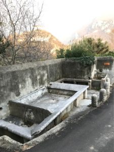
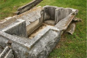
Boi washhouse-fountain
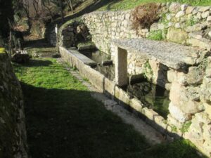
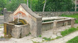 Si prosegue su via Porton, costeggiando un antico pozzo proprio di fronte il vecchio “Comun de Boi”. Si riattraversa la via principale Pesina-Caprino, fiancheggiando la carreggiata per circa 200 metri. A questo punto si sale, a sinistra, sulla strada delle “Fornase”, sulla destra si nota il lavatoio della contrada:
Contrada’s washhouse
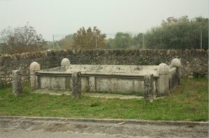
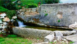
 Walk up and you will reach contrada Piozze, and an ancient cross, commissioned by Chignola’s family in 1839. Leaving Piozze there is the hamlet’s fountain-washhouse. fontana-lavatoio di Piozze:
Piozze fountain-washhouse
 Continue west and, turning right, you arrive at Casetta and then the localities of Le Tane and Moschetta. From here you go down towards the only road that flanks, to the north, the park of Villa Negrelli and, once you reach the crossroads, keep left, skirting the locality of Castel, an ancient prehistoric castle; you arrive at the cemetery which incorporates the remains of the primitive parish church of Pesina present since 1460, dedicated to Santa Cecilia. You go down the road lined with cypress trees and arrive at the starting point.
C2 – Caprino/Rubiana/Gaon/Caiar
Rubiana di Sotto washhouse
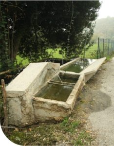
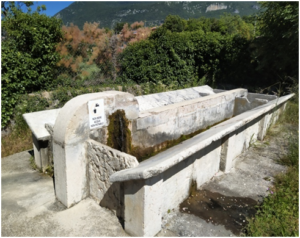
 Si prosegue sino ad incontrare via San Lorenzo, si svolta a destra e poi, prima del bivio, sul sentiero a destra fino a ritrovare l’abitato. Una breve rampa, superata la strada, porta nella piazzetta su cui si affaccia la chiesa di S. Eurosia su cui è posta una lapide che ricorda i rastrellamenti nazifascisti del 28 gennaio 1945. Quindi si scende fino ad incontrare la stradina che da Rubiana porta a Gaon, che si raggiunge (prendendo a sinistra) in una decina di minuti circondati da viti ed alberi da frutto. Giunti a Gaon si prende a sinistra in leggera salita e si raggiunge in pochi metri il bel lavatoio vicino a casa Zeni, per poi, ritornando sui propri passi, in breve giungere alla fontana-lavatoio di Gaon:
Gaon di Sopra washhouse
Fountain-washhouse of Gaon di Sotto
Una breve deviazione ci porta nel centro della frazione alla chiesa di S. Rocco:
Church of S. Rocco
 deserve to be visited. Downhill until Casette, go on and on the right side you can admire another fountain, the remains of a mill, the house where Enrico Fermi (Physicist, Rome Sept. 29th 1901, Chicago Nov. 28th 1954) stayed in 1925. In a few minutes you are in Caiar, where you can admire a sundial, a fresco and a Pink Fountain (1827). bella fontana racchiusa all’interno di mura quadrate.
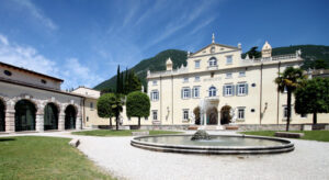
 Continue walking and you will arrive at Cometti which used to be a marble factory then, after about 500 metres turn right and you will arive at the starting point. Villa Carlotti.
C3 – Platano/Pazzon/Tasso/Porcino/Lubiara
To be seen
Wash-house of Villa Nichesola, Mill of Val Secca, Wash-house of Porcino and Lubiara, Valle del Tasso and “Gorgo” del Tasso. The waterways retraces ancient paths where we find fountains, wash houses, mills that testify to the ingenuity of man and his way of organizing the territory and its resources. Departure in Platano where it is possible to visit Villa Nichesola (open on weekdays), and the wash house located in the garden, at the exit of the watercourse of the villa’s pond. lWashhouse collocato nel giardino all’uscita del corso d’acqua del laghetto della villa.Wash house
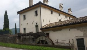
 Si sale alla frazione di S. Martino con l’omonima chiesa-oratorio del XIII secolo, casa dell’Abate e lavatoio. La strada prosegue verso nord con a sinistra lo stabile Bertoldi e figli, che un tempo era un mulino, e a destra un piccolo lavatoio. Si prosegue fino alla provinciale per Spiazzi e girando a destra si giunge ad uno dei mulini di Val Secca, con funzione di segheria per legname, con ruota e canaletta in pietra ripristinati e funzionanti:
Mills of Val Secca
 Proseguendo verso Spiazzi si arriva a Villa Cariola, più avanti sulla sinistra si vede la sorgente Fontana e Capitello detta Mascheron. Si prosegue fino a Pazzon con la fontana, scavata in unico blocco di marmo rosso Verona.
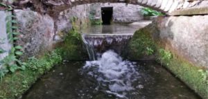
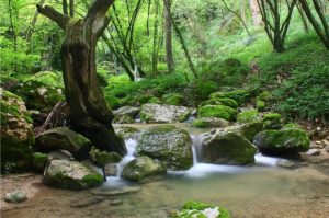
A destra della fontana si prende il sentiero per la Val del Tasso, dove si incontra un pregevole lavatoio, quindi si prosegue fino alla valle con il “Gorgo”, una cascata naturale del torrente:
Proseguendo verso Spiazzi si arriva a Villa Cariola, più avanti sulla sinistra si vede la sorgente Fontana e Capitello detta Mascheron. Si prosegue fino a Pazzon con la fontana, scavata in unico blocco di marmo rosso Verona.
A destra della fontana si prende il sentiero per la Val del Tasso, dove si incontra un pregevole lavatoio, quindi si prosegue fino alla valle con il “Gorgo”, una cascata naturale del torrente:
Val del Tasso
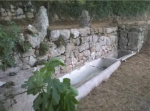
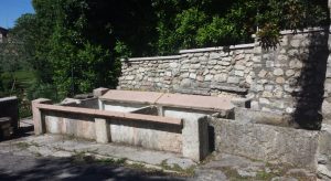
 Si prosegue verso la località Porcino, famosa nel secolo scorso per la fabbrica dei “copi”, coppi di Porcino; ancora oggi sono visibili le fornaci. In questa contrada vi è la fontana-lavatoio in marmo rosso Verona:
Fountain-sink in Verona red marble
 Si sale alla frazione di Cimaino e da qui, con un bel panorama sulla vallata di Caprino e sul Monte Baldo, si arriva in località Ori di Sopra, si prende la strada per le cave di marmo e si sale per 200 mt, per poi scendere a destra verso Località Gamberon. Qui girando a sinistra si arriva a Lubiara, tenendo la strada per Caprino, si incontra prima la bella fontana, e più avanti il lavatoio:
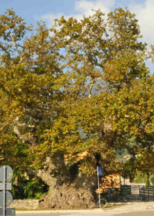
 Arrived at Villa Colpani-Becherle-Sandri, turn left and go down to a small capital, continuing to the right you come to another capital. Returning up the steps to the capital, you can go up to the courtyard of the Sometti complex and visit the wash houses. Turning right you arrive at the Villa dei Camini (Mountain), at the Platano dei 100 Bersaglieri and passing the bridge you return to the parking lot in front of Villa Nichesola’.